
When an Aging Shopping Center Becomes Housing, the ALTA Survey Sets the Baseline
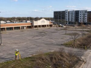
An ALTA survey creates the factual starting point for turning a tired shopping center into housing. These properties look simple from the parking lot and rarely are underneath. What reads as one site is often several parcels, a few outparcels and a stack of agreements written when the center was built. Parking gets shared. Utilities cross ownership lines. Signs and canopies sit on ground the owner may not control. Sorting all of that out on one drawing is what lets a redevelopment move forward with confidence.
Documenting the Existing Commercial Parcel Configuration
The survey first establishes what the property actually is. A shopping center that operates as a single business may sit on four or five separate legal parcels. Pad sites for a bank or a restaurant often carry their own ownership. The surveyor researches each parcel, recovers the boundaries, and shows how the pieces fit together.
Ownership lines rarely follow the pavement. A parking lot that serves the whole center may cross three parcels owned by different entities. The main building may straddle a lot line that no one has thought about in years. The survey reveals those internal lines, which matters because a housing redevelopment usually needs to replat the whole thing.
Getting the configuration right early prevents expensive surprises. A developer planning to demolish and rebuild needs to know exactly which parcels they’re buying, which they’re leasing, and where one ends and the next begins.
Mapping Reciprocal Parking and Access Agreements
Shopping centers run on shared-use agreements, and those govern the redevelopment. A reciprocal easement agreement typically lets every tenant’s customers park anywhere and drive through the whole site. Those rights attach to the land, which means they survive a sale unless they get formally changed.
The survey maps what those agreements cover. Crews locate the shared drive aisles, the parking fields, the access points and the connections to neighboring properties. The surveyor plots the agreement boundaries from the recorded documents and shows them against the physical site.
Conversion to housing collides with these rights directly. An agreement guaranteeing a departed anchor store a set number of parking spaces can block a plan to build on that lot. Cross-access that routes traffic through the site may conflict with a quiet residential layout. Seeing those rights mapped lets the developer identify what has to be renegotiated or released before design gets serious.
Locating Utilities That Serve Several Buildings
Utilities in an old center were built to serve the whole property, not individual parcels. One water service, one electric feed or one storm system often serves several buildings through lines that cross parcel boundaries freely. Those shared runs create problems when the property gets divided for housing.
Crews locate the visible evidence. Manholes, valve boxes, transformers, meters, cleanouts and pedestals all get mapped with elevations where they can be reached. Marked lines from a locate request and information from record drawings get added, with notes on where each came from.
The redevelopment has to account for shared service. A storm line running from a parcel that gets demolished across one that gets kept has to be rerouted or granted a formal easement. Finding those crossings on the survey, before demolition, keeps a wrecking crew from cutting a line that half the site still depends on.
Identifying Signs, Canopies, and Other Possible Encroachments
Commercial sites accumulate encroachments over the years. A pylon sign may sit on a neighbor’s parcel or in the public right of way. Canopies, drive-through lanes, trash enclosures and light poles may cross internal lot lines or easement boundaries. Each one is worth knowing about before a sale.
The survey measures and shows each crossing. A monument sign standing on a parcel the developer isn’t buying becomes a real issue if that sign is part of the property’s identity. A drive aisle that clips an easement affects what can be built there. Precise locations turn vague concerns into specific items to resolve.
Some encroachments favor the buyer and some don’t. The neighbor’s landscaping may cross onto the site, or the site’s own pavement may sit on adjoining land. The survey documents both directions so the developer enters negotiations knowing exactly where they stand.
Establishing a Record Before Demolition and Replatting
The finished survey becomes the reference for everything that follows. Once demolition starts, the evidence of how the site was configured disappears. Foundations get removed. Pavement gets stripped. The lines between old parcels vanish under a graded field.
Capturing conditions first protects the whole project. The ALTA survey records the parcels, the agreements, the utilities and the encroachments as they exist. Title companies use it to clear the way for closing. Attorneys use it to identify which agreements need action. Planners use it to prepare the replat that will create the new housing parcels.
Design teams work from the same document. An architect laying out the first housing concept needs to know where the buildable ground is once the shared rights and utility corridors are accounted for. The survey gives them a base they can trust instead of a set of assumptions about a property nobody has measured in thirty years.
For a free land surveying quote, call us at (703) 854-9783 or send us a message by going here.
Posted in alta survey