
Small Infill Parcels, Tight Grades, and the Value of a Detailed Lot Survey
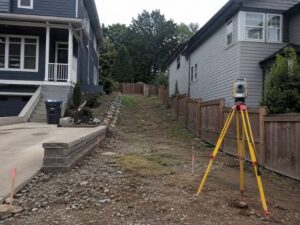
A lot survey on a small, built-up residential parcel does more digging than most people expect, sometimes literally. These lots have been improved for decades. Fences run along the edges. Landscaping covers the corners. Retaining walls, driveways and patios sit right where the original property markers were set. Before anyone can plan an addition or replace the house, a surveyor has to find those buried corners and measure how everything crowds together. That work is where a real infill project starts.
Recovering Corners on a Heavily Improved Residential Lot
Finding the corners is the hard part on an old lot. The original iron pins may sit under six inches of soil, behind a fence post, or under a slab poured forty years ago. Crews search with metal detectors, dig carefully at computed positions, and check what they find against the record.
One found marker rarely settles it. A surveyor needs enough evidence to prove the whole boundary, so crews look for corners on neighboring lots, cuts in old sidewalks, and any monument that ties the block together. Each piece gets measured and weighed against the deed and the plat before a line gets held.
Sometimes the markers are simply gone. Where that happens, the surveyor reconstructs the corner from the surrounding evidence, using the positions that did survive plus the recorded dimensions. That reconstruction follows established rules about which evidence outranks which, so the result can stand up if a neighbor questions it later.
Measuring Close Relationships With Neighboring Improvements
Small lots put everything close to the line, and those distances matter. Crews measure the neighbor’s house, garage, fence, driveway and any retaining wall near the boundary. A house sitting two feet from the line changes what can be built on the other side of it.
Encroachments turn up often on tight lots. A neighbor’s eave may overhang the property. A shared driveway may sit mostly on one parcel. A fence may run a foot inside the true line. Each of those gets shown with a measurement, since the owner and their designer need to know before they plan against it.
Those close distances also affect construction itself. Building near an existing foundation limits how deep a new excavation can go without shoring. Knowing the exact gap between the proposed work and the neighbor’s wall lets a structural engineer plan support before the digging starts.
Collecting Spot Elevations Around Existing Foundations
Grade information comes next, and it centers on the buildings. Crews shoot elevations at the corners of the existing house, along the foundation, at door thresholds and across the yard. Those points show how the ground sits against the structure right now.
Small elevation changes drive real decisions on a tight lot. A yard that drops eight inches from the house to the rear fence tells the designer where water goes and how much room exists for a walkout, a patio or a drainage swale. Guessing at those numbers produces a design that fights the site.
Foundation elevations connect the old work to the new. An addition has to match the existing floor level or step to it deliberately. A replacement house has to tie into the driveway, the sidewalk and the neighbors. Measured elevations give the architect the starting points for all of it.
Testing Whether the Proposed Layout Fits the Available Space
The survey answers a blunt question: does the plan fit? On a small lot, setbacks, coverage limits and access requirements eat the available space fast. Crews provide the exact dimensions that let a designer check each one.
Setbacks come first. A proposed addition has to sit inside the required front, side and rear yards, and on a narrow lot the side yards are usually the tight ones. The survey shows precisely how much room remains once the existing house and its projections get measured.
Coverage and access follow. Many districts cap how much of a lot can be covered by buildings and pavement, and an addition plus a wider driveway can push a tight lot over the limit. The survey supplies the measured existing coverage so the designer can see how much room is left before the plan gets drawn.
Preparing Reliable Base Data for the Grading Plan
Everything the crew collects becomes the base for the design drawings. Architects and engineers draw on top of the survey, so its accuracy sets the ceiling for everything that follows. A boundary that’s off by a foot produces a permit set that’s off by a foot.
The grading plan depends on the elevation data especially. A designer setting finished floor, planning drainage and shaping the yard needs the existing surface measured closely. On a compact lot with neighbors on every side, water has to be handled carefully, and that starts with accurate ground elevations.
The survey stays useful through permitting and construction. Reviewers check the proposed work against the surveyed conditions. Contractors build from the same base. When the design changes during review, the surveyed information gets updated so the drawings stay tied to the real lot rather than an approximation of it.
For a free land surveying quote, call us at (703) 854-9783 or send us a message by going here.
Posted in lot survey