
How Topographic Surveys Improve Grading Plan Accuracy
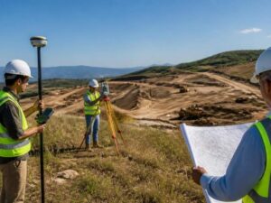
A grading plan is only as good as the ground data behind it. Guess the elevations, and the whole design drifts off. Topographic surveys give your engineer the real shape of the site, measured point by point. For developers in Fairfax , that data is what keeps a grading plan buildable instead of hopeful. Get it wrong, and you pay for it in change orders.
Accurate elevation data early saves money later. A good survey turns a rough idea into a plan that fits the land. That is the difference between smooth earthwork and a stalled site.
Why Accurate Site Elevation Data Is Essential for Grading Plans
A grading plan tells crews where to cut, fill and slope the dirt. All of that rests on elevation data. If the numbers are off by a foot, the plan is off by a foot everywhere it counts.
Bad elevation data shows up fast in the field. Water pools where it should drain. Cut and fill volumes miss the mark, so trucks haul the wrong amount of soil. Slopes end up too steep or too flat to pass review.
Good data does the opposite. It lets the engineer set pad heights, drainage paths and slopes that match the real site. The plan then works on paper and in the dirt. That match is the whole point of grading.
How a Topographic Survey Supports Precise Grading Design
A topographic survey maps the up-and-down shape of your land. The surveyor records ground elevations across the whole site. Those points become contour lines your engineer can design against.
The survey feeds grading design in a few clear ways:
- It sets a known vertical datum, so every elevation ties to the same baseline.
- It shows existing slopes, high spots and low spots that control drainage.
- It maps how water enters and leaves the site today.
- It gives the raw numbers for cut and fill calculations.
- It creates a base surface the design grade sits on top of.
Modern crews collect this data with GPS, total stations and drones. The result is a dense set of measured points, not a rough sketch. Your engineer builds the grading plan on that surface. Better input means a design that needs fewer fixes down the line.
Key Site Features Surveyors Capture Before Grading Begins
Elevations are the start, not the finish. A survey also records the physical things that shape how you grade. Miss one, and the plan may clash with what is already there.
Surveyors typically capture:
- Existing ground elevations and contours across the site.
- Drainage features like ditches, swales, inlets and outfalls.
- Streams, wetlands and other water edges that limit grading.
- Existing structures, pavement, curbs and retaining walls.
- Utility surface features such as manholes, valves and meters.
- Trees, tree lines and other features worth saving or clearing.
Each feature carries an elevation and a location. That lets the engineer grade around what stays and plan for what goes. Tie-in points at the property edges matter too, since your site has to meet the roads and lots next door. Skip those, and the new grades may not connect.
Common Grading Problems Accurate Surveys Can Help Prevent
Most grading headaches trace back to weak elevation data. A solid topographic survey heads off the worst of them. You spend a little up front and dodge big costs later.
Here are problems good survey data helps prevent:
- Standing water and poor drainage from grades that run the wrong way.
- Wrong cut and fill volumes that blow the earthwork budget.
- Retaining walls sized off bad numbers, then redesigned mid-job.
- Slopes that fail plan review and force a resubmittal.
- Runoff that dumps onto a neighbor and starts a dispute.
- Utility conflicts where a pipe sits higher or lower than assumed.
None of these are rare. They show up any time crews build on guessed elevations. A survey does not erase every risk, but it removes the ones caused by bad data. For a developer, that means fewer surprises after the machines arrive.
When a Topographic Survey Should Be Completed Before Construction
Order the survey early. It belongs in due diligence and design, not after grading starts. Waiting turns a cheap step into an expensive one.
Good times to get one:
- Before you buy, so you know the site can grade the way you need.
- Before the engineer starts the grading and drainage design.
- Before you set a budget for earthwork and site costs.
- Before you submit plans to the county for review.
- After major site changes, like clearing or an old demolition.
The survey should be current. Land moves, erodes and gets reworked, so old data can mislead. A fresh topographic survey gives the design team ground truth before a single load of dirt moves. That timing keeps the whole project on schedule.
Frequently Asked Questions
What is the difference between a topographic survey and a boundary survey?
A topographic survey maps elevations and physical features across a site. A boundary survey marks where your property lines run. Grading plans need the elevation data a topographic survey provides. Many projects order both, since they answer different questions.
How accurate does elevation data need to be for grading?
Grading design usually needs elevation data accurate to a fraction of a foot. The exact tolerance depends on the site and the local review standards. A licensed surveyor collects data that meets accepted survey accuracy for the job. That precision keeps cut, fill and drainage numbers reliable.
Can drones replace ground crews for a topographic survey?
Drones speed up data collection and cover large or rough sites well. They still work under a licensed surveyor who checks the results against ground control. On many sites, crews mix drone data with GPS and total station work. The goal is accurate, verified data, whatever tools produce it.
How long is a topographic survey good for?
A topographic survey reflects the site on the day it was measured. If the land stays untouched, the data can hold for a while. Clearing, grading, erosion or demolition can make it outdated. Order a fresh survey when the ground has changed since the last one.
Do I need a topographic survey for a small site?
Small sites still have slopes, drainage and tie-in points that affect grading. A survey right-sized to the lot gives the engineer real numbers to design with. Skipping it on a tight or sloped site invites drainage and earthwork problems. A surveyor can scope the work to match the size of the job.
For a free land surveying quote, call us at (703) 854-9783 or send us a message by going here.
Posted in land surveying, land surveyor | Tagged topographic survey