
How a Property Survey Helps Homeowners Plan Additions Without Encroaching on Neighboring Land
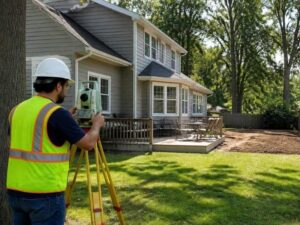
You have room in the backyard. You picture a bigger kitchen, a new garage, maybe a deck. It looks easy from where you stand. But the yard you see is not always the land you own. A property survey shows where your lot really ends and where your neighbor’s begins. That single fact can save you from building over a line that was never yours. This article explains how a property survey helps you plan an addition that stays on your own land.
Why Home Additions Require More Than Measuring Available Yard Space
A tape measure and a fence line feel like enough. They are not. Fences often sit in the wrong spot, sometimes by a foot or more. Old markers move. Grass hides the real corners of your lot.
Your buildable space is shaped by more than open ground. Setbacks tell you how far a structure must sit from each property line. Recorded boundaries show the legal edges of your lot, not the visible ones. Easements can block building in spots that look wide open. Existing structures, like a shed or driveway, take up room too.
A property survey pulls all of this into one clear picture. It gives you facts before an architect draws a single line. Start here, and you plan on solid ground instead of a guess.
Identifying the Actual Buildable Area Before Designing the Addition
A property survey marks the true location of your lines. It also maps what already sits on your lot. You see the house, the driveway, trees, slopes and other features in their real spots.
This tells you where an addition can actually go. Maybe the deck fits on the south side but not the east. Maybe the garage needs to shift six feet to clear a setback. A survey answers these questions early.
That saves money and time. Plans built on real measurements rarely need a full redo. You avoid the pain of loving a design, then learning it can’t be built.
How Property Surveys Reveal Hidden Issues Near Proposed Building Areas
Some problems don’t show on the surface. You can’t spot them by walking the yard. A survey brings them to light before you dig.
Common findings include:
- A structure sitting too close to a boundary
- A driveway or walkway that crosses onto a neighbor’s land
- An easement running through your planned build area
- An old fence, shed or slab that reaches over a line
Each of these can stall a project. Finding them early gives you choices. You can shift the design, fix the issue or plan around it before money is spent.
Coordinating Survey Information With Architects, Contractors, and Permit Requirements
Good survey data makes everyone’s job easier. Architects design within your real limits, not rough ones. Contractors know exactly where they can and cannot build.
The information matters for permits too. Most local offices want to see existing conditions and property lines before they approve an addition. A current survey shows both. It helps your application move without extra back and forth.
Rules change from one town to the next. Setback limits, permit steps and zoning codes vary by area. A licensed surveyor works with current local records, so your plans match what your local office expects.
Protecting Neighbor Relationships During Home Expansion Projects
New construction near a shared line can make neighbors nervous. Unclear boundaries make it worse. When nobody knows the real edge, small doubts grow into disputes.
A professional property survey gives both sides a fact to point to. It relies on records, not on guesswork. Both neighbors can look at the same line and trust it.
Confirming boundaries before you build protects more than the friendship. It heads off stop-work orders, legal fights and costly tear-downs. A clear line up front keeps the whole project calmer and cheaper.
Frequently Asked Questions
Do I really need a property survey to build a home addition?
In most cases, yes. Many permit offices ask for a current survey before they approve an addition. Even where it isn’t required, a survey protects you from building over a line by mistake. It’s a small cost next to the price of moving a finished structure.
How is a property survey different from what’s on my deed or plat?
A deed or plat describes your lot on paper. A property survey confirms those lines on the actual ground. It marks real corners and shows where features sit today. When the paper and the ground disagree, a survey helps sort out the truth.
Can a property survey show easements that affect my addition?
Yes. A survey can map recorded easements that cross your lot. These are strips where a utility or another party holds certain rights. Knowing where they run helps you keep your addition out of a spot you can’t legally build on.
What happens if my fence is not on the real property line?
This is common, and a survey will catch it. Your fence might sit inside your lot or slightly over your neighbor’s. Building off the fence line instead of the true line can lead to an encroachment. A survey shows the correct boundary so you build in the right place.
How long is a property survey good for before an addition?
There’s no single expiration date, but fresh is better. If the last survey is old, new fences, sheds or grading may have changed the picture. Many homeowners order an updated survey when planning a major addition. Check with your local permit office, since some want a survey done within a set time frame.
For a free land surveying quote, call us at (703) 854-9783 or send us a message by going here.
Posted in land surveying, land surveyor | Tagged boundary survey