
How a Licensed Land Surveyor Identifies Buildable Areas on Challenging Lots
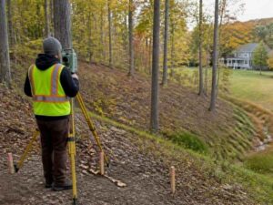
Some lots look bigger than they build. A parcel can show plenty of open ground and still leave you a tight, awkward spot to place a structure. A licensed land surveyor is the person who tells you the difference before you buy or design. They separate the ground you can use from the ground that only looks usable. For a developer, that early read can save a plan that would have failed on paper.
A Challenging Lot Needs More Than a Simple Property Line Check
A property line map tells you where the land ends. It doesn’t tell you where you can build. Those are two different questions, and hard lots make the gap wide.
Steep slopes eat into usable space. Odd boundaries leave narrow corners you can’t do much with. Easements, drainage swales, thick trees, and old structures all take a bite out of the plan. On a first visit, the lot may seem ready. Walk it with a survey in hand and the picture changes.
That’s why a full check matters more on tricky sites. You’re not just confirming the corners. You’re finding every feature that shrinks or shifts where a building can go. Skip that step and you can pay for land you can’t fully use.
Survey Evidence Shows Where the Usable Ground Actually Begins and Ends
Before anyone talks about building spots, the true property limits have to be pinned down. That starts with research, not measurement. The surveyor pulls the deed, the recorded plat, and past survey records to see how the parcel was defined.
Then the field work begins. The surveyor locates monuments, pins, and other physical evidence on the ground. They compare what’s marked in the dirt to what the records claim. When those two disagree, they apply survey rules to settle the real line.
This step sets the frame for everything after it. A building area only means something once the boundary is solid. Get the line wrong and every plan built on top of it is wrong too. Get it right and you have a firm edge to design against.
Elevation Changes Can Shrink a Building Area Without Changing the Lot Size
A flat map hides the shape of the land. Two lots can be the same size on paper and build nothing alike. The difference is what sits between the high points and the low ones.
The surveyor maps the contours and grade changes across the site. A steep drop can rule out a whole corner. A low pocket may collect water and push the structure elsewhere. Retaining walls can reclaim some slope, but they cost money and take space of their own.
Here’s what elevation work often reveals on a hard lot:
- Slopes too steep to build on without heavy grading
- Low areas that hold water and limit foundation options
- Grade breaks that force a smaller or shifted footprint
- Spots where a retaining wall is the only way to gain ground
None of this shows up on a plat. It shows up when someone measures the land in three dimensions. For a developer, that data decides whether a lot pencils out or not.
Recorded Restrictions Can Remove Apparently Open Ground From the Building Plan
Open grass can be off limits. The ground may be flat, clear, and completely unbuildable because a document says so. The survey brings those limits to the surface.
Easements are the common one. A utility easement running across the middle of a lot can split your usable area in two. A right-of-way along the front can push the building back further than you expected. Setbacks from each line carve a smaller box inside the boundary, and that box is where you actually get to build.
Flood-related limits add another layer. If part of the lot sits in a mapped flood area, that ground carries rules that can raise cost or block certain uses. The surveyor flags these constraints so they land on your plan early, while you still have room to adjust. Finding them after design is set is where budgets break.
The Final Survey Helps Turn a Difficult Lot Into a More Realistic Site Plan
Add all of it together and the survey gives you a usable building envelope. Not the whole lot. The part that’s truly free of slope problems, easements, setbacks, and flood limits. That envelope is the honest starting point for design.
From there, your team works with real ground instead of guesses. The designer places the structure where it fits. The engineer plans access and drainage around known features. You can weigh future improvements against space you know you have. Each decision rests on measured facts, not a hopeful look at an open field.
That’s the value of bringing a surveyor in early on a hard lot. You trade surprises for a plan you can trust. A difficult parcel becomes a site you can actually price, design, and build with your eyes open.
Frequently Asked Questions
How early should a developer hire a surveyor on a difficult lot?
Bring one in before you close or start design, not after. A survey done early shows the real building area while you still have room to negotiate or walk away. Waiting until design is set means any bad news forces expensive rework. The earlier you know the limits, the more options you keep.
Can grading or retaining walls make an unbuildable slope usable again?
Sometimes, but it comes at a cost. Retaining walls and heavy grading can reclaim sloped ground, yet they add expense, take up space, and may need their own permits. The survey shows how steep the slope really is, which tells your engineer if the fix is worth it. That math should happen before you commit to the lot.
What survey work best captures elevation on a challenging site?
A topographic survey maps the contours, grade changes, and low spots that affect where you can build. It turns the shape of the land into data your design team can use. On steep or uneven lots, that detail often decides the whole layout. Ask your surveyor whether the site calls for one.
Does a buildable area shown by a surveyor guarantee I’ll get a permit?
No, the survey shows physical and recorded limits, but permit approval also depends on local zoning and review. The buildable area is your realistic starting box, not a final sign-off. Your design still has to meet the rules that apply to that parcel. Use the survey to plan, then confirm the plan with the local authority.
How do easements change what I can build on open ground?
An easement gives someone else a right to use part of your land, even if it looks empty. You usually can’t build over a utility or access easement, so it removes that strip from your plan. The survey maps each one so you see the real usable space. That keeps you from designing on ground you don’t fully control.
For a free land surveying quote, call us at (703) 854-9783 or send us a message by going here.
Posted in land surveying, land surveyor | Tagged land surveyor, land surveying