
Easement Conflicts a Boundary Survey May Uncover Before a Home Addition
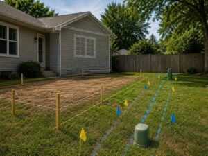
Planning a home addition often starts with a simple question about how far a new wall can extend, but the real answer depends on more than just the property line. Recorded easements can cross a yard in places an owner never expected, quietly limiting where new construction can go. A boundary survey brings these hidden rights into view before design work gets too far along.
Skipping this step can lead to an unpleasant surprise midway through permitting, when a reviewer flags an easement that nobody on the project team knew was there.
Matching the Deed to the Physical Property
Before anything else, the surveyor has to confirm exactly where the legal property lines sit, tying the written deed description to physical evidence found on the ground. This step gives the whole project a reliable starting point.
Slope, easements, and every other constraint mean little until this foundation is set. A design based on a rough guess about where the property line runs risks being built around the wrong assumptions entirely, which is why this confirmation always comes first.
Plotting Utility Corridors Near the Existing House
Once the boundary is confirmed, the surveyor turns to recorded utility easements, since these often run alongside or rear yards exactly where a homeowner hopes to build. Plotting these corridors accurately shows how much of the buildable yard is actually available.
A side yard that looks wide open can end up mostly covered by a utility easement running its full length. Seeing this clearly on the survey drawing, rather than discovering it later, gives a homeowner and their designer the chance to plan the addition around it from the very start.
Distinguishing Visible Use From Documented Rights
Not everything visible on a property matches what is actually recorded, and not everything recorded is visible on the surface. A worn path, a buried pipe, or a utility pole might hint at an easement, but only the recorded document confirms its true extent and location.
Sorting through this distinction takes careful review. A surveyor compares what can be seen and measured in the field against the documents pulled from the public record, since relying on visible clues alone can miss rights that exist purely on paper.
Checking the Addition Footprint Against Every Constraint
With the boundary, easements, and setbacks all mapped together, the proposed addition footprint can finally be checked against the full picture. This step often reveals conflicts that were not obvious when the addition was first sketched out on a simple site plan.
Seeing every constraint layered onto one drawing helps a homeowner understand exactly where the addition can and cannot go. It also gives the design team a clear starting point for adjusting the footprint if a conflict does turn up during this review.
Referring Unclear Easement Language for Legal Review
Some easement documents are written clearly, while others use vague or outdated language that leaves real questions about what is actually permitted within the easement area. A surveyor can locate these documents and show where the easement sits, but interpreting unclear legal language goes beyond what a survey is meant to answer.
When this kind of ambiguity comes up, referring the document to an attorney is the appropriate next step. This keeps the survey focused on measurable facts while leaving legal interpretation to the professionals trained to handle it.
Frequently Asked Questions
Can an easement exist even when nothing is visible?
Yes. A recorded right can remain fully valid without any obvious sign of it on the surface of the property.
Does the surveyor decide whether building inside an easement is permitted?
No. The governing document, the easement holder, legal counsel, and the reviewing authority may all play a role in that decision.
Should a title report be provided for a residential survey?
It can be valuable, especially when identifying every recorded easement is an important goal of the project.
For a free land surveying quote, call us at (703) 854-9783 or send us a message by going here.
Posted in Boundary survey