
Boundary Evidence Hierarchy When Deeds, Plats and Occupation Lines Disagree
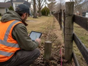
A boundary evidence hierarchy is the order a surveyor follows when the clues about a property line don’t agree. Deeds say one thing, an old plat says another and a fence sits somewhere else entirely. Rather than picking a favorite, a surveyor ranks the evidence by long-settled rules. That ranking decides which clue controls when they conflict.
Why Boundary Evidence Does Not Carry Equal Legal Weight
Not all evidence about a line deserves equal trust. A mark set by the original surveyor speaks with more authority than a number copied years later. Courts and surveyors have long recognized this order.
The ranking rests on a simple idea. Evidence closest to the original creation of the boundary usually controls, since it reflects what the parties actually intended. Later measurements, however precise, come second to that intent.
This is where senior rights and controlling calls come in. Certain evidence outranks the rest by rule, not by preference. A surveyor applies that order rather than guessing which clue looks best.
Evaluating Original Monuments and Their Replacements
A monument set when the boundary was created carries great weight. Natural monuments like a river or a marked tree, and artificial ones like an iron pin, can control a line even over written measurements. Finding an original monument often settles a corner.
Replacements need more scrutiny. A pin set later to stand in for a lost original may or may not sit in the right spot. The surveyor studies witness evidence and records to judge whether a found marker is truly original or a later substitute.
Disturbance complicates the picture. A monument knocked loose or moved loses some of its authority. The surveyor weighs the condition of each marker before leaning on it.
Comparing Written Dimensions with Physical Evidence
Deeds carry bearings, distances, acreage and sometimes coordinates. These written dimensions matter, but they often yield to stronger physical evidence. A monument on the ground can outrank a distance written in a deed.
The order among written elements has its own logic. A call to a monument generally controls over a course, a course over a distance and a distance over an area or coordinate. This sequence guides the surveyor when the numbers clash.
The reason lies in reliability. A physical mark reflects where the line was actually run, while a written number can carry a copying error. The hierarchy favors the evidence least likely to be wrong.
Understanding the Role of Adjoining Deeds and Senior Conveyances
A property line is shared, so the neighbor’s deed matters too. Adjoining descriptions can confirm or challenge how a line reads. A surveyor studies both sides rather than one deed in isolation.
The order of conveyances carries weight. When a large tract was split over time, the earlier, or senior, deed generally holds its full description, and the later, junior, parcel takes what remains. This seniority can decide an overlap.
Reading these relationships takes care. A gap or overlap between neighbors often traces back to the sequence of sales. Understanding that order helps the surveyor resolve the conflict correctly.
Documenting a Professional Boundary Opinion
A boundary decision is a professional opinion built on evidence. The surveyor gathers the research, the field findings and the analysis, then explains how the hierarchy led to the conclusion. That reasoning is what stands behind the line.
Honest documentation includes uncertainty. Where the evidence is thin or conflicting, the surveyor says so rather than pretending to certainty. A clear record of doubt is more useful than false confidence.
Some conflicts exceed the surveyor’s authority. When evidence truly can’t settle a line, the matter may need legal resolution between the owners. The surveyor marks that boundary and points the parties toward the right process.
For a free land surveying quote, call us at (703) 854-9783 or send us a message by going here.
Posted in Boundary Surveying